FAQ about Mountain Rwenzori hiking safaris – Guide to Mountain Rwenzori hiking safaris.
Mountain Rwenzori hiking safaris
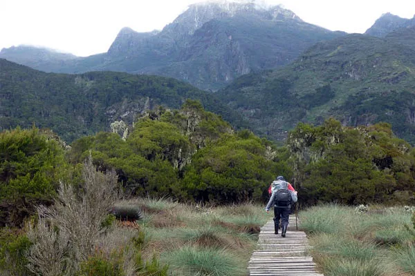
Every adventure traveller visiting Africa is captivated by the unique adventure experiences in Africa. The Rwenzori Mountains are home to a diverse range of plant and wildlife species, and hiking through the various vegetation zones offers a truly unforgettable and unforgettable adventure. While hiking up to the Rwenzori mountain peaks, you may see a variety of animals, including mammals, monkeys, and reptiles, as well as flora that ranges from dense tropical rain forests to bamboo forests, montane forests, and alpine vegetations, all of which combine to provide stunning scenery.
Three million years ago, the Rwenzori Mountains supposedly came into being. It is made up of a collection of mountain ranges called massifs, which are cut apart by valleys and steep canyons that contain flora and lakes. There are several massifs in the area, including Stanley (5,109 m), Speke (4,890 m), Baker (4,843 m), Emin (4,798 m), Gessi (4,715 m), and Luigi di Savoia (4,627 m). The Rwenzori Mountains are around 150 km in length and 60 km in width.
Greek travelers seeking the Nile’s source referred to Mount Rwenzori as the Mountains of the Moon. According to a traveler named Diogenes, the native inhabitants of the area gave the mountains that formed the Nile its name, the Mountains of the Moon, due to the whiteness of their snowy summits. Sadly, the amount of snow on the mountains has been decreasing, and soon it will be entirely. Rwenzori Mountains National Park and three other sites are the highlights of Uganda’s cultural landscape.
In how many days might one expect to climb the Rwenzori Mountains’ tallest peak?
On Mount Rwenzori, there is a path.
At 5,109 meters above sea level, Margherita Peak on Mountain Stanley is the highest point in the Rwenzori Mountains. Hiking to this peak takes anything from seven to ten days.There are several summits in the Rwenzori Mountains from where you may have a good view of the four main mountains: Margherita, Savoia, Great Tooth, and Elena. From Elena, you can see Mountain Stanley, which is to the left. Mount Speke and Mount Baker, both visible from Weismann’s Peak, are positioned in the center.
How much money would one need to climb Mount Rwenzori?
How many days and how much money you have to climb Mount Rwenzori are the two most important factors to consider. We provide comprehensive and personalized trekking trips to Mount Rwenzori, including the ten-day trek, which covers the arduous ascent to four summits (Margherita Peak, Mt Speke, Mt Baker, and Weismann’s Peak on the return) and costs $1,640. Entrance fees to the Uganda Wildlife Authority (UWA) gate are $35 each day, payable individually in cash; prices start at $1,520 for one or two people and go to $3,520 for three or more.
All meals, lodging, and porters while on the mountain are included in the price. A one-day woodland walk along the Munyamubuli River offers a shorter trip to Mountain Rwenzori; along the way, visitors may see birds, learn about different tree species, and enjoy scenic views.
The cost of this hike is Each additional person must pay an additional $35 per day in cash to enter the Uganda Wildlife Authority (UWA) gate; the cost is $40 per person for one or two people and $35 per person for three or more people. The price covers all meals and porters. Get in touch with us, and we’ll take care of booking your Mountain Rwenzori trekking package or any other one you may choose.
Guide to Mountain Rwenzori hiking safaris
Once we have this information, we will inform you of the next step in the booking process. In order to guarantee that all of the services for your trip are secured in advance, we will send you an invoice for payment after you confirm your booking with us. At the park headquarters, we will cover the cost of trekking and admission fees so that you may proceed on the climb to one of the greatest peaks in the Rwenzori Mountains.
When is the best time to plan a hike in the Rwenzori Mountains?
The Rwenzori Mountains are available for a hiking adventure at any time of year. Climbing Mount Everest. As a result of climate change, the lower glaciers are melting and changing at a faster rate than in the past, making the ascent of steep sections and bogs all the more difficult. Climbing the main peaks, such as Margherita Peak, the highest peak of Rwenzori Mountain, is no picnic. However, the guides have extensive training and expertise using ropes to assist you on your climb and descent of the mountain.
Time of year to visit or go hiking on Mount Rwenzori
Because of its location along the Equator, which sees both dry and rainy seasons, the Rwenzori Mountain remains dormant all year round. This makes it one of the most distinctive tourist destinations along the Equator. The national parks of Bwindi Forest, Virunga, and Volcanoes are situated in the tropics, so they all experience tropical and montane climates and weather all year round.
The rains in these parks can come at any time, but the best time to visit is during the dry season, which begins in December and continues through February, June, July, August, and September. The trails are much easier to walk in these months, and the vegetation isn’t fully grown, so seeing gorillas is easier and clearer during this time. March, April, May, October, and November are the other somewhat rainier months; most tourists avoid going
gorilla trekking during these times due to the fully grown foliage and the very treacherous routes.
What is the location of the Rwenzori Mountains?
Rwenzori Mountains National Park is home to the “Mystical Challenge” of the Rwenzori Mountains. The Rwenzori, also known as the Mountains of the Moon, are Africa’s tallest mountain range, and they were the snowy source of the Nile that early geographers mentioned. Located in western Uganda, Rwenzori Mountains National Park protects the highest portions of the 150-kilometer-long and 65-kilometer-wide Rwenzori Mountain Range, which borders Congo.
Seventy mammalian species and two hundred and seventeen avian species, including nineteen indigenous to the Albertine Rift, call this national park home. You may immerse yourself in the local culture and learn about the Bakonzo way of life on nature walks, bird watching, sightseeing, and mountain Rwenzori hikes, among many other attractions and activities.


